Article

Nature-Based Solutions vs. Human-Induced Approaches for Alpine Grassland Ecosystem: “Climate-Help” Overwhelms “Human Act” to Promote Ecological Restoration in the Three-River-Source Region of Qinghai–Tibet Plateau

1
China Grassland Research Center, School of Grassland Science, Beijing Forestry University, Beijing 100083, China
2
College of Grassland Science, Shanxi Agricultural University, Jinzhong 030801, China
3
CAS Key Laboratory of Forest Ecology and Management, Institute of Applied Ecology, Chinese Academy of Sciences, Shenyang 110016, China
4
Department of Landscape Architecture, School of Architecture, Tsinghua University, Beijing 100084, China
*
Author to whom correspondence should be addressed.
Remote Sens. 2024, 16(7), 1156; https://doi.org/10.3390/rs16071156
Submission received: 2 February 2024 / Revised: 18 March 2024 / Accepted: 23 March 2024 / Published: 26 March 2024

Abstract

:
How climate change and human activities drive the evolution of the regional environment and where the quality of ecosystems improve or decline over time have become widespread concerns. In this study, we took the Three-River-Source (TRS) region of the Qinghai–Tibet Plateau as a case, aiming to identify and quantify the contribution of the natural and anthropogenic factors to the ecosystem changes over the past years from 1980 to 2018 using the methods of remote sensing and spatial statistical analysis. Based on the land cover map interpreted by reference to satellite remote sensing imagery data, we defined the Ecological Restoration Area Proportion (ERAP) as the bare land patch decrement to indicate the ecologically restored quantity in space. Assembling the restoration project information, we digitalized and vectorized the ecological Restoration Intensity (RI) including the spatial range and temporal duration. Combining the ERAP and the net primary productivity (NPP), which indicates the quantity and quality of ecosystems, respectively, the ecological asset Index (EAI) was developed and calculated. Having integrated the datasets of the vegetation monitoring, climatic factors, geographical factors, and human activities, we performed multi-variable analysis of the attribution of how the change in the EAI, the NPP, and the EAI have been affected by these factors together. The NPP of the middle and eastern parts of the TRS region has improved the most, as the average growth rate of NPP reached approximately 2.5 kg C/m2/10a. Due to such dynamic pattern, we found that human-induced re-vegetation has made limited contributions in our multi-regression model as the variance explained by the RI merely amounts to 4.4% to 8.8%, while the changes were mostly dependent on the regional temperature and the precipitation which contributed over 45% to the ecological restoration on average. It was summarized that “climate-help” overwhelms “human act” in such alpine grassland ecosystem. The regression results for the different aspects of the ERAP and NPP demonstrated that the ecological restoration project helped most in regard to ecosystem quality improvement rather than the restored ecosystem quantity. Our study has developed a comprehensive assessment methodology that can be reused to account for more ecological asset. The case is an example of an alpine ecosystem in which the success of ecological restoration needs favorable climatic conditions as supporting evidence for the nature-based solution.

Graphical Abstract

1. Introduction

The Qinghai–Tibet Plateau (QTP) is a unique and world-renowned ecoregion that can be regarded as a typical area affected by climate change and human disturbance [1]. Covered mainly by alpine grassland ecosystems, the QTP is the birthplace of the major rivers in Asia. The stability and health of the grassland ecosystem in the region is critical to ensure sustainable development in downstream watersheds, where billions of people and livelihoods depend on the ecological services provided by upstream ecosystems [2].
Human activities and climate change have severely disturbed the natural ecosystems of the QTP [2]. The ecological degradation and restoration in the QTP in the past half-century reflect the demand driven by the population, economic development, and readjustment aroused by the increasing environmental awareness [3]. The main ecological degradation is caused by the overgrazing of grassland ecosystems. The Tibetan Plateau has an average altitude of about 4000 m above sea level and an area of about 2.4–2.6 million km2. It boasts a unique alpine grassland covering up to 1.4 million km2, which forms the main body of the terrestrial ecosystem of the Plateau under cold, arid, and strong radiation climatic conditions. This grassland plays a crucial role in conserving biodiversity, soil and water, acting as a carbon sink, and regulating the climate [4]. The alpine grasslands on the Tibetan Plateau are crucial to the terrestrial ecosystem. They are home to 5.3 million herders and 58,599,600 head of livestock, which are highly dependent on them for survival [5]. However, overgrazing has been a serious issue in recent decades, with rates ranging from 27% to 89% [6]. This poses a significant challenge to the sustainability of the region.
The Three-River-Source (TRS) region, namely the sources of the Yellow River, Yangtze River, and Lancang-Mekong River, is a significant ecoregion on the QTP that is facing severe ecosystem degradation, including soil erosion, desertification, and disruption of runoff. To address ecosystem degradation and mitigate environmental impacts on the upper mountainous and lower watersheds of the Yellow, Yangtze, and Lancang-Mekong rivers, the Qinghai Province government has implemented significant ecological restoration projects with the guidance and support of the central government [7]. The aim of these projects is to integrate biological, ecological, engineering, and economic measures to facilitate large-scale reconstruction and restoration of grasslands and wetlands. This will help prevent ecosystems from being affected by overgrazing and land-use change [8]. These projects primarily focus on restoring grassland and wetland ecosystems.
In recent years, numerous remote-sensing-based monitoring and assessment endeavors have been conducted globally, particularly in ecologically sensitive or significant areas, aiming to harmonize the preservation of natural ecosystems with the utilization of socio-economic resources while bolstering natural capital management [9,10,11,12]. These initiatives encompass a range of methodologies and approaches. For example, researchers have devised an integrated methodology operating at the national scale, employing the Driver-Pressure-State-Impact-Response framework to map ecosystem services [13]. Others have leveraged remote sensing data products to compute vegetation indicators, facilitating rapid assessments of ecosystem health [14], while some have employed net primary productivity as a proxy for estimating ecosystem quality [15]. However, despite the breadth of existing research, previous studies on natural capital measurement have largely overlooked the simultaneous definition and differentiation of both quantity and quality aspects. Furthermore, there exists a notable dearth of quantitative analyses concerning driving forces, particularly regarding the incorporation of spatial and temporal data on ecological restoration efforts within anthropogenic activities for detailed examination of their contributions. While previous research has often focused on macroscopic spatial associations based on pattern analysis, the historical dynamics of ecosystems at the microscopic level, coupled with ground survey data, have been overlooked. This highlights a critical gap in the current literature and underscores the need for more comprehensive and nuanced approaches to understanding the multifaceted dynamics shaping natural capital management.
Addressing these identified gaps and aiming to introduce a novel methodology for the comprehensive integration of ecological restoration measurement, ecosystem quality assessment, and other driving forces, our study focuses on the TRS region as a case study area. We endeavor to incorporate both quantity and quality dimensions into the assessment of ecological asset within this region. Leveraging ground survey data, we have developed new restoration intensity indicators tailored to specific restoration methods, such as artificial grassland establishment and fencing protection. By integrating spatial and temporal dimensions, these indicators enable the transformation of on-site ecological restoration engineering information into quantifiable variables, thereby acknowledging the significant role of human intervention and its contribution to restoration efforts. Drawing inspiration from the notion of “human act and climate-help” prevalent in China’s atmospheric pollution control field [16], we extended this paradigm to the realm of grassland ecological restoration. Acknowledging the symbiotic relationship between human endeavor and environmental conditions, our study aims to elucidate the intertwined effects of natural and anthropogenic factors on regional ecological asset. Specifically, our objectives include elucidating changes in ecological asset and discerning the respective impacts of human actions and climate facilitation on ecological recovery within the TRS region over the past decades. Through a quantitative and spatially explicit approach, we would like to shed light on the dynamic interplay shaping the ecological landscape of this region, offering insights crucial for informed decision-making and sustainable management practices.

2. Materials and Methods
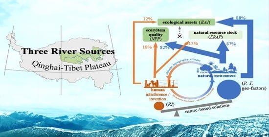
2.1. Study Area

The Three-River-Source region is located in the center of the Qinghai–Tibet Plateau (Figure 1). The three major rivers, the Yangtze River, the Yellow River, and the Lancang-Mekong River in Asia originate in the mountain peaks in this region. The alpine steppe and meadow ecosystems cover over 90% of the region’s territory and the lakes and the wetlands scattered over the area are connected by a network of rivers and streams. The altitude is approximately 3500 m above sea level on average and the topographical features of the plateau shape the local grassland ecosystems as a fragile environment harboring unique habitats for both wildlife and nomadic Tibetan people over thousands of years, offering a vast land for grazing and water resources.
In the early period before the 1980s, the ecosystems were less interfered with by human activities with a few main infrastructures. From the 1980s to 2000s, under the compounding impacts of climate change, livestock overgrazing, and land use change, the regional environment showed apparent degradation and the downstream areas experienced severe droughts and serious floods several times. The desertification and shrinkage of lakes and wetlands happened at an accelerating pace in the region. Until the beginning of the 21st century, the ecological degradation in this region was initially mitigated by years of re-vegetation efforts, together with the improved climate. Still, the development of highways and other infrastructures in the river source region has continued growing in recent decades, which is a double-edged sword fragmenting the alpine wildlife habitats landscape while facilitating ecosystem services to open to the outside world and the exchange of different civilizations to harmonize the relationship between the plateau and the inner land societies. In 2015, the central government initiated the Chinese National Park Program and investment to save the completeness and authenticity of the ecosystems with key values in a holistic manner. The Three-River-Source region was selected as one of five Chinese National Parks as the first batch and the priority one. The ranges of the three sub-parks corresponding to the three source areas were defined. The responsibilities and rights to protect and uplift the quality and capitalization of the regional ecosystems’ goods and services at national and local levels became clearer and more effective in the aspect of administration and legalized governance for natural resources.

2.2. Data Collection

In order to monitor and assess the ecological restoration and perform the analysis on the ecological asset and the driving forces, we collected a series of remote-sensing-based products as the fundamental and input layers to be integrated with the ground surveyed data. Considering the regional scale of the case, we selected the raster datasets of the 30 m resolution land use/cover change (LUCC), 5 km resolution vegetation net primary productivity (NPP), 1 km resolution annual temperature and precipitation, 250 m resolution digital elevation model layer, and 1 km resolution other geographical factor layers. The LUCC data and the NPP data represent the quantity and the quality of the ecosystem, respectively, and the datasets of the finest resolution that we could find were used in our study. For the other layers of environmental drivers, we prioritized the longer time series and temporal continuity, and considered accessibility in collecting and compiling them for the analysis in a well-aligned, multi-dimensional way. Value extraction and statistical analysis were performed after resampling all layers to a 5 km resolution.
Our analysis of climate drivers was limited to temperature and precipitation. It was based on the assumption that temperature represents the energy environment, while precipitation indicates hydrological cycling. These two factors simplify and generalize the climatic effects on ecological restoration. The climate datasets for these two factors were the most complete and accessible in terms of their continuity over space and time. However, it is important to note that the regional climate is influenced by various factors beyond temperature and precipitation. The regional climate is a complex system that includes elements such as wind, humidity, atmospheric pressure, and solar radiation. However, these elements are highly correlated with the two climatic variables [17]. Our focus is on identifying the main drivers of natural and human-induced factors, rather than exploring the interplay of multiple variables within the climate system itself. To achieve this, we restricted our analysis to temperature and precipitation as representative variables.
(1) 
Land use/cover change and the ecological restoration area proportion. We collected land use/cover change maps for the years 1980, 1990, 1995, 2000, 2005, 2010, 2015, and 2018, 8 periods in total, which were interpreted and classified from the satellite imagery dataset of the Landsat sensor series at 30 m spatial resolution from the online platform (http://www.resdc.cn/, accessed on 20 March 2024). The accuracy of the classification is over 70% [18]. For the purpose of monitoring the ecological degradation and restoration in the region, we redefined and reclassified the land cover types into vegetation-land and barren-land, i.e., vegetation-land containing forest/shrubs and grassland, and barren-land meaning desert. In the TRS region, which is predominantly covered by alpine grassland ecosystems, ecological degradation mainly refers to the transition from grassland and forest/shrubs to bare ground [19], and thus the barren-land patches in the region show where and how ecological degradation occurred in the alpine grassland and wetlands across space. The decrement of the bare-land patches area proportion was defined as the ecological restoration area proportion (ERAP). The area proportion changing rate of these barren-land patches over the years in the resampled grid of 10 km grain size was calculated to measure the ecological degradation level and spatial distribution.
E R A P = ( a r e a α a r e a β ) / a r e a 1980
where a r e a α means the after annual barren-land area, a r e a β means the before annual barren area, and a r e a 1980 means the barren-land area in 1980.
(2) 
Net primary productivity. Since over 90% of areas in the region are covered by grassland in the study area, we used the net primary productivity (NPP) of the vegetation as the indicator of the ecosystem quality which was estimated on the basis of the satellite imagery data over the past decades. The datasets of NPP (1982–2018) were acquired from the platform of the National Earth System Science Data Center, National Science & Technology Infrastructure of China (http://www.geodata.cn, accessed on 20 March 2024). The spatial resolution is 5 km, and the temporal resolution is 8 days. The annual average of NPP was calculated based on the raster layers of the 8-day NPP dataset product from January to December by stacking and applying the Mosaic Operator in ArcGIS 10.8. The original data source for calculating NPP was derived from the satellite data of the AVHRR series, as the land cover type information was based on the MODIS Global Land Categories Product “MCD12C1” (https://e4ftl01.cr.usgs.gov/MOTA/, accessed on 20 March 2024). Theoretically, in the CASA model, NPP is estimated using the absorbed photosynthetically active radiation (APAR) and the real LUE [20].
N P P   ( x ,   t ) = A P A R   ( x , t ) × ε   ( x , t )
where NPP (x, t) represents the NPP at month t for grid position x (unit: gC · m−2 · month−1), APAR (x, t) is the APAR at month t for grid position x (unit: MJ · m−2 · month−1), and ε (x, t) is the real LUE (unit: gC · MJ−1) [21]. APAR is determined by both the total solar radiation and the characteristics of the plant canopy, and can be calculated as:
A P A R   ( x ,   t ) = 0.5 × S O L   ( x , t ) × f A P A R   ( x , t )
where SOL represents the total solar radiation, which can be obtained by establishing the relationship model between the sunshine duration included in the meteorological dataset and the solar radiation for grid position x (unit: MJ · m−2 · month−2) [22]. fAPAR (x, t) is the fraction of APAR absorbed by the plant canopy, where 0.5 represents the proportion of the radiation which can absorbed by plants (0.38–0.71 μm) [23].
(3) 
The calculation of the ecological asset index. We used the ecological asset index (EAI) to comprehensively reflect changes in the quality and quantity of the ecosystems by following Ouyang et al.’s (2020) method as per Equation (4).
E A I i = n = 1 5 ( E A i n × E Q I ) E A i × 5 × E A i 2500000 × 10 4
where i means the different types of ecosystem, such as forest/shrubs, grassland, wetland, desert, and glacier. In our case, the EQI means the degree of ecosystem quality transferred from the NPP level by the different types of ecosystem (Table 1), which means the area of the type i ecosystem.
(4) 
Climatic factors. The annual average temperature (T) and annual precipitation (P) data were collected from the National Meteorological Interpolation Data Products provided by the Chinese Academy of Sciences Resource and Environmental Science and Data Center platform. The spatial resolution of the original data is 1 km, one scene per year, and the time range is from 1980 to 2015, with a total of 36 years. Similar to the calculation method of the dynamic change rate of the ecosystem, we estimated the overall scale of the study area, divided the space grid with 50 km as the side length, and calculated the dynamic change rate of the average temperature and precipitation of each grid point for each grid point. The linear regression was performed with the annual mean value as the dependent variable and the year of the time series as the independent variable to obtain the distribution of climate factor slope values as the impacts of climatic factors.
(5) 
Geographical factors. The digital elevation model (DEM) was collected from the geographic data platform (http://geodata.pku.edu.cn, accessed on 20 March 2024) of the School of Urban and Environment, Peking University, including 250 m resolution raster layer data across the country. We used the DEM to perform slope calculation in QGIS 3.16 and generate a sloped raster layer as a percentage. Elevation and slope were topographical factors affecting the formation and changes of ecosystems in a digital form [24]. Soil erosion grades were downloaded from the shared dataset provided by the Chinese Academy of Sciences’ resource and environmental science and data center platform and the data was 1 km resolution raster layer data. Different types of soil erosion methods were combined according to the original data to grade soil erosion standards, ranging among slight, mild, moderate, strong, extremely strong, and severe erosion with grades of 1 to 6. Integrating various information about topography, wind, water, and soil structure, the soil erosion degree was used to quantitatively reflect the effect of land elements on the dynamics of regional ecosystems.
The wilderness distribution map is a spatially continuous raster layer that reflects the relative intensity of human activities at the landscape scale [25]. This layer was collected from the relevant datasets during 2015 to 2018, which showed the distribution of human activity intensity patterns on the QTP’s ecosystems in this period. By assembling and grading the naturalness of land use, population density, distance from settlements, distance from roads, settlement density and road density, and weighted linear stacking, we applied a generated integrated indicator, the National Wilderness Quality Index (WQI), which is represented by Equation (5), with a resolution of 1 km [25]. The Human Activity Index (HAI) was calculated by subtracting WQI from 1 to quantify the relative intensity of human activities following Equation (6).
W Q I = 1 n X i × w i
HAI = 1 − WQI
(6) 
Information of the ecological restoration actions and intensities. We collected the information and atlases of ecological restoration projects from 2005 to 2013 from local departments to assemble and digitalize a dataset. The ecological restoration project was divided into two types: artificial grassland construction (human-induced restoration) and grassland fencing (nature-based restoration). According to the different restoration measures and engineering characteristics, we constructed a quantitative indicator “ecological restoration intensity” that integrates the spatial and temporal features of the ecological restoration measures by referring to previous ecological restoration impact assessment models [26]. We developed this indicator based on the assumption that the longer the recovery time, the larger the area, and the closer the distance from the restoration implementation site, the greater the restoration intensity and impact. The calculation formula for this indicator is represented by Equations (7) and (8). For the overlaps of artificial grassland construction and grassland protection projects, we normalized and summed them up as per Equation (9).
R I A = l n ( 2018 y e a r ) R 2
R I F = l n [ ( 2018 y e a r ) × a r e a × c e n t r a l i t y ]
R I t a = R I A R I A _ m i n R I A _ m a x R I A _ m i n + R I F R I F _ m i n R I F _ m a x R I F _ m i n
where RIA—artificial grassland restoration intensity; RIF—grassland fencing restoration intensity; RIta—the total restoration intensity.

2.3. Statistical Analysis

To determine the impact of the primary driving forces and identify their effects in a composite multi-regression model, we employed a step-wise model selection process based on corrected Akaike’s information criterion (AIC; ΔAIC < 2) to select the best predictors of the dependent variables. This procedure was performed by using the function “dredge” in the R package MuMIn [9]. Model averaging was performed based on AIC weights when multiple models were selected. Model residuals were inspected for constant variance and normality. All predictors and response variables were standardized before analyses using the Z-score to interpret parameter estimates on a comparable scale. Predictors were log-transformed, when necessary, before analysis to meet the assumptions of the tests used. We evaluated the relative importance of the predictors under considerations of drivers of dependent variables, i.e., ERAP, NPP, and EAI. We calculated the relative effect of the parameter estimates for each of the predictors, i.e., the partitioned variance contribution (as a percentage). To perform the variance decomposition analysis, we transformed all predictors to Z-scores.
To draw a more generalized conclusion on the attribution of the climatic and anthropogenic factors for ecosystem change, we processed the preliminary results of the statistical analysis. First, we selected, according to the regression results, the mean of the climatic factors (T and P), and the human interference, quantified by the indicator of RI, and assembled the uniformly normalized values of them, as from the minimum to the maximum (represented in a range of 0 to 100%), over the years to examine when and how the effects of the climate and the restoration measurement happened to the alpine grassland ecosystem on the temporal dimension. Second, we summed the variance partitioning values by the specific factors with the categories of the human activities and the natural environment respectively to present the proportion of the two main kinds of driving forces in a quantitative and comparative manner. The processed results were used to summarize the mode of ecological restoration under both the natural and human dimensions.

3. Results

3.1. The Changes of the Ecosystem Quantity and Quality in the TRS Region

The results show that from 1980 to 2018, the overall ERAP, NPP, and EAI of the TRS region all have a significantly increasing trend (p < 0.0001) (Figure 2). The maximum increment rate of EAI could reach approximately 3%/10a. However, in a part of the region, the bare land patches increased by nearly 2%/10a, like on the eastern side of the Yellow River source, and some scattered spots on the eastern side of the Yangtze River. The spatial-temporal dynamics of NPP patterns showed that the ecosystem quality in the eastern counties at the Yellow River source, the southeastern Yangtze River source, and the Lancang-Mekong River source was notably improved, reaching about 2.5 kgC/m2/10a on average. Since the EAI showed a combination of the changes in both area and quality of vegetation as shown by the different types of ecosystems, its pattern exhibited a higher spatial heterogeneity. The overall EAI in the Yellow River source showed the fastest growth rate at the level of about 0.8/10a, and the figures for the eastern area of the Yangtze River source and the southeastern area of the Lancang River source were growing faster. The EAI in the western area of the Yangtze River Source remained steady. The EAI of Tongde County and Xinghai County in the eastern area of the Yellow River source and Golmud City declined significantly.

3.2. The Contributions of Climate, Geography and Human Factors to the Ecological Restoration of the TRS Region

The attribution ratio and the regression coefficients of the impact factors to the ERAP, the NPP, and the EAI of the region are presented in Figure 3 (p < 0.05, the confidence intervals were drawn as the length of the bars in the forest graphs). The results show that the regional climatic factors are the most dominant variables affecting the ecosystem restoration, exceeding 45% of the total contribution. Generally speaking, the higher the regional mean temperature, the faster the conversion rate of bare land patches to the grassland, and also the higher the appreciation of ecological asset. The increase of precipitation showed the most significantly positive effects on the NPP, namely 29.5% of variance contribution to the accumulation of NPP. Regarding geographical factors, both altitude and slope showed significant correlations with the EAI and the ERAP. For the NPP, the lower altitude was more conducive to NPP accumulation. The regression model shows that altitude was one of the major factors inhibiting the increase of the NPP (the contribution rate is negative 32.8%). The ecological restoration projects indicated by the metric of RI showed a greater positive impact on the improvement of ecosystem quality, accounting for about 8.9% of the total contribution. Notably, road construction showed positive implications for the accessibility of ecological restoration and conservation measures, but may also cause problems such as landscape fragmentation and soil hardening. Our analysis suggested that roads have a relatively positive effect on the improvement of the NPP and the EAI, but no significant effect on the ERAP.

3.3. Temporal-Spatial Variations of Ecological Restoration and Driving Factors

The input layers of the environmental impact factors suggested that from 1980 to 2018, the temperature in the TRS region has significantly increased and the precipitation has varied greatly across the space (Figure 4). Having selected the most significant driving factors, the average annual temperature, average annual precipitation, and the RI, the spatial regression coefficients of the pairs between these factors and the ERAP, the NPP, and the EAI by county unit were obtained and mapped (Figure 5). It can be seen that the precipitation was significantly negatively correlated with the ERAP and the EAI in the eastern area of the TRS region and near the Yellow River source. The warmer and dryer climate in this region has seriously limited the ecological restoration and caused the ecological asset increment to decline. The annual average temperature of the TRS region showed a positive effect on the overall vegetation restoration, but it should be noted that the increased temperature and reduced precipitation were unlikely to promote the NPP in the northeast part of the region. The RI was of positive significance to the improvement of the ecosystem quality in most of the TRS region. However, there was less correlation between the RI and EAI in some areas of the Yellow River source and the Lancang-Mekong River source. It is alarming that RI did not play a fully positive role in Golmud, Gonghe, Jainca, and Henan counties in both the quantity and quality of the ecological restoration.

3.4. A More Generalized Track and Attribution on the Ecosystem Restoration under the Driving Forces

In the synthesized results of the changing trends of the ecosystem indicators and their main driving forces, the whole process in the study area over the past decades can be divided into three phases (Figure 6a): (1) the first phase of the ecosystem degradation in 1980~1995, (2) the second phase of the ecosystem restoration in 1995~2005, and (3) the third phase of the ecosystem stabilization after 2005. By the end of the first phase, we found that the ERAP, NPP, and EAI had severely declined and reached the bottom under the disadvantageous climatic condition, i.e., being dryer and colder in the region. As the P increased and the T rose, the positive human interference in the form of ecological restoration was observed, and the ecological indicators were promoted simultaneously. Notably, the ecosystem quality, or the NPP, improved more quickly due to human act. Afterwards, even during the year of 2015 which experienced continuous dry conditions and extreme drought, we found that the ecosystem area and the assets declined with limited speeds. Only the NPP showed sensitivity as it dropped more heavily although still not reaching the bottom in this phase. The regional ecosystem may acquire higher resistance under human act in the ecological restoration to combat drought, as it did not reach the bottom when faced with more severe drought in the years between 2013 and 2018.
By summing up the quantified proportions of the attribution of the natural and anthropogenic factors, we demonstrate how they differently affect the ecosystem assets directly, or via the area and quality indirectly, as the overall effect percentage (Figure 6b). The results indicate that human activities have affected the ecosystem quality more than the ecosystem area, while the climatic factors have affected the restored ecosystem area more than the restored ecosystem quality. We summarize and describe such differently weighted effects on the aspects of quantity and quality via combining the natural and human aspects as a leverage effect. This means that investment by humans coupled with natural environmental change function together in relation to the ecological asset.

4. Discussion

4.1. The Mode of “Human Act and Climate-Help” in the Ecological Restoration

The TRS region is a vital waterhead area and ecological barrier area in China and the East Asia continent. Long-term monitoring and scientific research have been conducted to detect the impact of climate change on the ecosystems in this region. Since the 1990s, China has implemented numerous ecosystem restoration projects to protect the environment in this region. From 2005 to 2015, local and central governments have invested about RMB 7.65 billion (equal to about USD 1.113 billion), initially reversing the trend of ecological degradation in some key areas [27]. From 2016 to 2025, the Chinese government is investing around RMB 17 billion (equal to about USD 2.42 billion) to rebuild the ecosystem structures and functions in this region. However, limited information can be obtained about the cause—effect of the ecological restoration interventions such as artificial grassland construction and grassland fencing. In our study, the spatial patterns of EAI and NPP suggest that there is no significant relationship between the enlargement of ecological restoration areas and the promotion of ecosystem quality. For instance, there has been a moderate rate of EAI increment and higher rate of NPP improvement in the eastern parts of the TRS region, including Maqên County, Tongde County, and Xinghai County, which have relatively low altitudes, a higher intensity of human activities, and higher grassland utilization, but also receives more investment in local environmental maintenance and governance [28]. Due to the continuous overgrazing by local pastoralists’ cattle, the overall bare land patches show no obvious decrement, even though the frequent human intervention of grassland restoration has helped maintain and promote the NPP. Our results show that both the quantity and quality of the vegetation in the Yellow River source, the eastern part of the Yangtze River source, the eastern part of the Lancang-Mekong River source and the intermediate zone between the Yellow and the Yangtze River sources have increased significantly and synchronically, the EAI has increased fast in the past decades. The pattern is basically consistent with the previous studies of the monitoring and analysis of the regional vegetation restoration [24].
Based on our results and previous studies, it can be concluded that the ecological restoration of the source of the Yellow River has exerted a “radiation effect” and “leverage effect” on the region in the past decades [29]. The “radiation effect” implies that the locally restored community can affect the radiated surroundings to some extent via biophysical or biochemical processes. The “leverage effect” implies that local restoration may probably leverage the multiple resources and the external advantageous climate conditions to expand the local achievement toward reaching a higher level of ecosystem development. The grassland restoration projects in the eastern part of the Yellow River source, the intermediate zone between the sources of the Yellow River and the Yangtze River, and around the Lancang-Mekong River source are most helpful for increasing the regional vegetation quality. At the same time, over the past years, the overall warming and humidification of the QTP is conducive to vegetation restoration, and the conservation and restoration process has been significantly accelerated by human interventions, forming a governance mode of “human act, climate-help”. Our results indicate that human factors have not made a great contribution, while the regional climate change has accounted for a larger contribution. However, it should be noted that human intervention is an important measure to curb the collapse of fragile ecosystems. Such policies and engineering timely play an irreplaceable and critical role in the transformation of micro-topography, micro-climate, and micro-environment, especially for the improvement of ecosystem structure and functioning, which will be a turning point in the ongoing evolution of the ecosystem [30]. We generalize this process as the “leverage effect”, i.e., using human interventions to amplify the effect of natural restoration and to reduce the risks of the ecosystem degradation under the trend of climate warming and humidification.

4.2. The Implications and Recommendations to Improve the Ecosystem Assets in the Alpine Grassland

Our study has quantitatively revealed that human activities, whether interference or intervention, have made limited contributions to the overall ecosystem restoration. However, human participation is essential in the evolution of the regional ecosystems. Artificial grassland planting of seedlings is more precise and controllable and enables community reconstruction but has limited radiated range since the labor cost per square kilometer in the plateau region is too high [10]. With regard to erecting fences for protection, it mainly depends on the natural recovery by simply removing the human interference and awaiting natural succession for many years. It covers a large area of grassland but has higher uncertainty. The recovery time as a result of protection through fencing usually takes longer than by carrying out artificial grassland planting. Now, based on the comparison mentioned at the beginning and the current analysis, we hereby suggest that only when these two methods are employed to jointly develop nature-based solutions will it be possible to fully restore the destroyed original plateau ecosystem like that in the TRS region. According to the results of our attribution analysis, climate has contributed basically over double that due to human act to ecosystem restoration in terms of both ERAP and NPP. The ecological restoration measures performed by humans mainly include grazing prohibition, hunting prohibition, artificial seeding, and artificial weather intervention. Thus, these measures have only a local direct effect to small extents as a mending of the bare land patches and an acceleration of natural evolution to assist the system to regain its resilience [31]. The ecosystem’s restoration and improvement of vegetation on a large scale are basically determined by nature’s influencing and nourishing role [32].
This nuanced analysis reveals that climate factors, i.e., regional temperature and precipitation, are overwhelmingly the primary contributors to ecological restoration success, accounting for over 45% of the variance, juxtaposed with minimally contributing human-induced re-vegetation efforts, and presents critical insight. This revelation underscores the predominant role of natural climatic conditions in facilitating ecological recovery and suggests a potential reevaluation of human-centric restoration strategies. The relatively low variance explained by Restoration Intensity (4.4% to 8.8%) in the multi-regression model signals a need to further scrutinize the efficiency and effectiveness of current human-led restoration projects.
From a broader ecological standpoint, these findings illuminate the resilience and dependence of alpine grassland ecosystems on climatic factors. The dominant influence of “climate-help” over “human act” in promoting ecological restoration in such ecosystems underscores the importance of aligning restoration strategies with natural climatic patterns and cycles. This alignment could enhance the efficacy of restoration efforts, ensuring that they complement rather than counteract the inherent ecological processes driven by climate.
Societally, the insights gleaned from this study have implications for environmental policy and land management practices. Here are the three main recommendations for the relevant improvement of policymaking and environmental governance. (1) Recognizing the limited impact of human-induced re-vegetation emphasizes the need for policies that prioritize the protection and enhancement of natural ecosystem processes. It suggests that conservation efforts should not only focus on active human interventions but also on creating conditions that facilitate natural restoration processes, such as protecting areas from further degradation and allowing ecosystems to recover through natural succession. (2) Policies should advocate for the integration of climate projections and environmental impact assessments into the initial planning stages of restoration projects. This will ensure that ecological restoration efforts are aligned with expected climatic conditions, thereby increasing the likelihood of success and sustainability of projects. Restoration initiatives should be designed to be flexible and adaptive to changing climate conditions, with mechanisms for ongoing monitoring and adjustment based on climatic feedback. (3) Resources for ecological restoration should be strategically allocated to areas identified through spatial analysis at the stage of planning as having the most favorable climatic conditions for restoration success. This targeted approach would maximize the ecological return on investments by focusing efforts where they are most likely to thrive, thereby optimizing the use of limited resources for maximum environmental benefit. By implementing these policy recommendations, governments and stakeholders can increase the effectiveness of ecological restoration projects, leveraging natural climatic advantages while ensuring that restoration efforts contribute to the resilience and sustainability of alpine ecosystems.

4.3. The Limitations and the Outlooks of the Study

The primary objective of our study was to devise an encompassing framework that serves as an integrative approach, addressing both the quantitative and qualitative dimensions of ecological asset while bridging the natural and human facets within alpine ecosystems. The criteria guiding indicator selection primarily centered on their representativeness and accessibility. However, the omission of more specific factors within the subsystems of natural and socio-economic compartments renders the current findings deficient in terms of their explanatory capacity and depth of detail. Notably, the regional climate system emerges as a pivotal driver influencing vegetation dynamics, intricately intertwined with hydrological cycling, particularly within this region characterized by river sources. Subsequent investigations should encompass elements such as runoff, evapotranspiration, cloud formation, soil water, and underground water to construct a more comprehensive model elucidating the natural forces from both hydrological and energy perspectives. This holistic approach promises to enhance our understanding of the intricate dynamics governing alpine ecosystems, thereby facilitating more informed management and conservation strategies.
While this study draws upon ample field survey data pertinent to ecological restoration initiatives, there exists a dearth of information concerning other ground surveys. Future research endeavors could benefit from systematic data collection and national-level open-source sharing initiatives, such as the Second Tibetan Plateau Scientific Expedition and the Ministry of Ecology and Environment’s inspections. These platforms offer avenues for delving deeper into issues that remote sensing methods alone may not fully elucidate. Within natural systems, investigating plant diversity holds promise, given its close correlation with productivity, ecosystem stability, and the foundational role that it plays in ecosystem services and values. The rich biodiversity of the TRS region, housing numerous rare and medicinally valuable species, warrants further exploration to unravel the intricate relationships among habitat quality, biodiversity, and ecological asset valuation within alpine grasslands.
The statistical test in our investigation unveiled the positive role of roads within alpine ecosystems. The conventional perspectives often cast road construction as disruptive and deleterious for the vegetation, as it typically causes substantial disturbances to the natural environment, including soil compaction, alterations in hydrology, habitat fragmentation, and changes in the distribution of plant species. Our findings, however, suggest a more nuanced narrative. The accessibility facilitated by transportation system development not only facilitates the implementation of ecological restoration projects but also catalyzes regional economic development, thereby engendering heightened levels of ecological awareness and environmental protection which are summarized in the theory of Environmental Kuznets Curve [33]. This study offered a view that road construction is a double-edged sword for alpine grasslands, underscoring the need for additional empirical studies to corroborate these findings. Such inquiries hold promise for advancing our understanding of the complex interplay between socio-economic dynamics and ecological integrity within alpine ecosystems.
In addition, monetization was not calculated in this study. When comparing the results of this study with ecological restoration project investment in the future, monetization is required to emphasize the utility value attribute of ecological asset [34]. The participation of multiple major stakeholders in ecological protection, and the delineation and utilization of protected areas is a problem of coupling natural and socio-economic systems, and the key area of the TRS region should be handled with caution and considering scientific references. In the next stage of study, it is expected that the methods of monetization of ecological asset will be developed as an integration with the economic research paradigm.

5. Conclusions

In this study, we developed a methodology using techniques of remote sensing and geoinformatics, and ground surveys to create a novel digital evaluation system for ecological restoration projects in regard to the dimensions of ecological restoration area, ecosystem quality, and their relationships with the impacting factors. By using this innovative and integrative methodology, the contribution of natural and human factors to ecosystem change have been clearly quantified in a spatially explicit manner. The results of this study suggest that human active intervention in restoring the grassland ecosystems will be of great significance to the maintenance of ecosystem quality, and also for the preservation and appreciation of ecological asset by taking advantage of the forces of regional climate change. Such “leverage effect” was conceptualized and applied to coordinate the conservation of ecological resources for and the socioeconomic development of the protected areas. The key findings from this study can provide sound foundations for improving the human-induced restoration interventions and offer strong evidence for advocating the nature-based solution strategies of ecosystem restoration of the QTP and the similar fragile critical eco-regions worldwide.

Author Contributions

Conceptualization, Z.L. and S.D.; methodology, Z.L.; software, Q.S.; validation, Q.S.; formal analysis, Z.W.; investigation, W.F.; resources, T.M.; data curation, Q.S.; writing—original draft preparation, Z.L.; writing—review and editing, Z.L., Y.X. and Y.C.; visualization, Z.L.; supervision, S.D.; project administration, Z.L.; funding acquisition, S.D. All authors have read and agreed to the published version of the manuscript.

Funding

This work was supported by grants from the Second Tibetan Plateau Scientific Expedition and Research Program (2019QZKK0307), the National Key R&D Program of China (2023YFF1304305), the National Natural Science Foundation of China (32101324), the National Foreign Expert Project (G2023109009L), the College Students’ Innovation and Entrepreneurship Training Program (X202310022372, X202310022374, X202310022376).

Data Availability Statement

Dataset available on request from the authors.

Conflicts of Interest

The authors declare no conflict of interest.

References

  1. Huang, K.; Zhang, Y.; Zhu, J.; Liu, Y.; Zu, J.; Zhang, J. The Influences of Climate Change and Human Activities on Vegetation Dynamics in the Qinghai-Tibet Plateau. Remote Sens. 2016, 8, 876. [Google Scholar] [CrossRef]
  2. Xiong, Q.; Xiao, Y.; Halmy, M.W.A.; Dakhil, M.A.; Liang, P.; Liu, C.; Zhang, L.; Pandey, B.; Pan, K.; El Kafraway, S.B.; et al. Monitoring the Impact of Climate Change and Human Activities on Grassland Vegetation Dynamics in the Northeastern Qinghai-Tibet Plateau of China during 2000–2015. J. Arid. Land 2019, 11, 637–651. [Google Scholar] [CrossRef]
  3. Wang, Z.; Zhang, Y.; Yang, Y.; Zhou, W.; Gang, C.; Zhang, Y.; Li, J.; An, R.; Wang, K.; Odeh, I.; et al. Quantitative Assess the Driving Forces on the Grassland Degradation in the Qinghai–Tibet Plateau, in China. Ecol. Inform. 2016, 33, 32–44. [Google Scholar] [CrossRef]
  4. Chen, H.; Ju, P.; Zhu, Q.; Xu, X.; Wu, N.; Gao, Y.; Feng, X.; Tian, J.; Niu, S.; Zhang, Y.; et al. Carbon and Nitrogen Cycling on the Qinghai–Tibetan Plateau. Nat. Rev. Earth Environ. 2022, 3, 701–716. [Google Scholar] [CrossRef]
  5. Wang, Y.; Lv, W.; Xue, K.; Wang, S.; Zhang, L.; Hu, R.; Zeng, H.; Xu, X.; Li, Y.; Jiang, L.; et al. Grassland Changes and Adaptive Management on the Qinghai-Tibetan Plateau. Nat. Rev. Earth Environ. 2022, 3, 668–683. [Google Scholar] [CrossRef]
  6. Zhang, Y.; Zhang, X.; Wang, X.; Liu, N.; Kan, H. Establishing the Carrying Capacity of the Grasslands of China: A Review. Rangel. J. 2014, 36, 1–9. [Google Scholar] [CrossRef]
  7. Cai, H.; Yang, X.; Xu, X. Human-Induced Grassland Degradation/Restoration in the Central Tibetan Plateau: The Effects of Ecological Protection and Restoration Projects. Ecol. Eng. 2015, 83, 112–119. [Google Scholar] [CrossRef]
  8. Rey, F.; Cécillon, L.; Cordonnier, T.; Jaunatre, R.; Loucougaray, G. Integrating Ecological Engineering and Ecological Intensification from Management Practices to Ecosystem Services into a Generic Framework: A Review. Agron. Sustain. Dev. 2015, 35, 1335–1345. [Google Scholar] [CrossRef]
  9. Gross, N.; Le Bagousse-Pinguet, Y.; Liancourt, P.; Berdugo, M.; Gotelli, N.J.; Maestre, F.T. Functional Trait Diversity Maximizes Ecosystem Multifunctionality. Nat. Ecol. Evol. 2017, 1, 0132. [Google Scholar] [CrossRef]
  10. Ou, M.; Lai, X.; Gong, J. Territorial Pattern Evolution and Its Comprehensive Carrying Capacity Evaluation in the Coastal Area of Beibu Gulf, China. Int. J. Environ. Res. Public Health 2022, 19, 10469. [Google Scholar] [CrossRef]
  11. Willis, K.S. Remote Sensing Change Detection for Ecological Monitoring in United States Protected Areas. Biol. Conserv. 2015, 182, 233–242. [Google Scholar] [CrossRef]
  12. Thien, B.B.; Yachongtou, B.; Phuong, V.T. Long-Term Monitoring of Forest Cover Change Resulting in Forest Loss in the Capital of Luang Prabang Province, Lao PDR. Environ. Monit. Assess. 2023, 195, 947. [Google Scholar] [CrossRef]
  13. Shmelev, S.E.E.; Agbleze, L.; Spangenberg, J.H.H. Multidimensional Ecosystem Mapping: Towards a More Comprehensive Spatial Assessment of Nature’s Contributions to People in France. Sustainability 2023, 15, 7557. [Google Scholar] [CrossRef]
  14. Abbaszadeh Tehrani, N.; Mohd Shafri, H.Z.; Salehi, S.; Chanussot, J.; Janalipour, M. Remotely-Sensed Ecosystem Health Assessment (RSEHA) model for assessing the changes of ecosystem health of Lake Urmia Basin. Int. J. Image Data Fusion 2022, 13, 180–205. [Google Scholar] [CrossRef]
  15. Zeng, H.-W.; Ling, C.-X.; Liu, H.; Zhao, F.; Wang, X.-M.; Zhang, Y.-T. Assessment of Ecosystem Quality Changes Based on Optimizing Key Indicators in Nanwenghe National Nature Reserve, Heilongjiang, China. Ying Yong Sheng Tai Xue Bao = J. Appl. Ecol. 2023, 34, 3064–3072. [Google Scholar] [CrossRef]
  16. Xu, Z.; Chen, S.; Wu, X. Meteorological Change and Impacts on Air Pollution: Results from North China. J. Geophys. Res. Atmos. 2020, 125, e2020JD032423. [Google Scholar] [CrossRef]
  17. Li, Z.; Liu, X.; Ma, T.; Kejia, D.; Zhou, Q.; Yao, B.; Niu, T. Retrieval of the Surface Evapotranspiration Patterns in the Alpine Grassland–Wetland Ecosystem Applying SEBAL Model in the Source Region of the Yellow River, China. Ecol. Model. 2013, 270, 64–75. [Google Scholar] [CrossRef]
  18. Xu, Y.; Yu, L.; Peng, D.; Zhao, J.; Cheng, Y.; Liu, X.; Li, W.; Meng, R.; Xu, X.; Gong, P. Annual 30-m Land Use/Land Cover Maps of China for 1980-2015 from the Integration of AVHRR, MODIS and Landsat Data Using the BFAST Algorithm. Sci. China-Earth Sci. 2020, 63, 1390–1407. [Google Scholar] [CrossRef]
  19. Wang, C.; Wei, M.; Wu, B.; Wang, S.; Jiang, K. Alpine Grassland Degradation Reduced Plant Species Diversity and Stability of Plant Communities in the Northern Tibet Plateau. Acta Oecologica 2019, 98, 25–29. [Google Scholar] [CrossRef]
  20. Wang, X.; Tan, K.; Chen, B.; Du, P. Assessing the Spatiotemporal Variation and Impact Factors of Net Primary Productivity in China. Sci. Rep. 2017, 7, 44415. [Google Scholar] [CrossRef]
  21. Zhu, W.; Chen, Y.; Pan, Y.; Li, J. Estimation of Light Utilization Efficiency of Vegetation in China Based on GIS and RS. Geomat. Inf. Sci. Wuhan Univ. 2004, 29, 694–698, 714. [Google Scholar]
  22. Abbaspour, K.C.; Vaghefi, S.A.; Yang, H.; Srinivasan, R. Global Soil, Landuse, Evapotranspiration, Historical and Future Weather Databases for SWAT Applications. Sci. Data 2019, 6, 263. [Google Scholar] [CrossRef] [PubMed]
  23. Zhu, W.; Pan, Y.; Long, Z.; Chen, Y.; Li, J. Estimating Net Primary Productivity of Terrestrial Vegetation Based on GIS and RS:A Case Study in Inner Mongolia, China. Natl. Remote Sens. Bull. 2005, 3, 300–307. [Google Scholar] [CrossRef]
  24. Shao, Q.; Cao, W.; Fan, J.; Huang, L.; Xu, X. Effects of an Ecological Conservation and Restoration Project in the Three-River Source Region, China. J. Geogr. Sci. 2017, 27, 183–204. [Google Scholar] [CrossRef]
  25. Cao, Y.; Carver, S.; Yang, R. Mapping Wilderness in China: Comparing and Integrating Boolean and WLC Approaches. Landsc. Urban Plan. 2019, 192, 103636. [Google Scholar] [CrossRef]
  26. Wang, Y.; Li, Z.; Zheng, X. The Microclimatic Effects of Ecological Restoration in Brownfield Based on Remote Sensing Monitoring: The Case Studies of Landfills in China. Ecol. Eng. 2020, 157, 105997. [Google Scholar] [CrossRef]
  27. Zhai, X.; Liang, X.; Yan, C.; Xing, X.; Jia, H.; Wei, X.; Feng, K. Vegetation Dynamic Changes and Their Response to Ecological Engineering in the Sanjiangyuan Region of China. Remote Sens. 2020, 12, 4035. [Google Scholar] [CrossRef]
  28. Lü, L.; Zhao, Y.; Chu, L.; Wang, Y.; Zhou, Q. Grassland Coverage Change and Its Humanity Effect Factors Quantitative Assessment in Zhejiang Province, China, 1980–2018. Sci. Rep. 2022, 12, 18288. [Google Scholar] [CrossRef]
  29. Guo, H.; Wei, Y.; Yang, Z.; Wang, X.; Wen, M.; Yang, L.; Zhao, L.; Haiyan, Z.; Zhou, P. Ecological Restoration Is Not Sufficient for Reconciling the Trade-off between Soil Retention and Water Yield: A Contrasting Study from Catchment Governance Perspective. Sci. Total Environ. 2020, 754, 142139. [Google Scholar] [CrossRef]
  30. Liu, Y.; Yang, P.; Zhang, Z.; Zhang, W.; Wang, Z.; Zhang, Z.; Ren, H.; Zhou, R.; Wen, Z.; Hu, T. Diverse Responses of Grassland Dynamics to Climatic and Anthropogenic Factors across the Different Time Scale in China. Ecol. Indic. 2021, 132, 108341. [Google Scholar] [CrossRef]
  31. Lopez-Juambeltz, F.; Rodriguez-Gallego, L.; Dabezies, J.M.; Chreties, C.; Narbondo, S.; Conde, D. A GIS-Based Assessment Combined with Local Ecological Knowledge to Support the Management of Juncus Acutus L. Spreading in the Floodplain of a Protected Coastal Lagoon. J. Nat. Conserv. 2020, 57, 125891. [Google Scholar] [CrossRef]
  32. Qin, J.; Si, J.; Jia, B.; Zhao, C.; Zhou, D.; He, X.; Wang, C.; Zhu, X. Water Use Characteristics of Two Dominant Species in the Mega-Dunes of the Badain Jaran Desert. Water 2022, 14, 53. [Google Scholar] [CrossRef]
  33. Hardy, C.L.; de Rivera, C.E.; Bliss-Ketchum, L.L.; Butler, E.P.; Dissanayake, S.T.M.; Horn, D.A.; Huffine, B.; Temple, A.M.; Vermeulen, M.E.; Wallace, H.; et al. Ecosystem Connectivity for Livable Cities: A Connectivity Benefits Framework for Urban Planning. Ecol. Soc. 2022, 27, 36. [Google Scholar] [CrossRef]
  34. Ma, G.; Wang, J.; Yu, F.; Yang, W.; Ning, J.; Peng, F.; Xiafei, Z.; Zhou, Y.; Cao, D. Framework Construction and Application of China’s Gross Economic-Ecological Product Accounting. J. Environ. Manag. 2020, 264, 109852. [Google Scholar] [CrossRef]
Figure 1. Study area: The Three-River-Source region of the Qinghai–Tibet Plateau, China.
Remotesensing 16 01156 g001
Figure 2. The changing rate of the ecological restoration area proportion (ERAP) (%/10a) (a); of the net primary productivity (NPP) (kgC·m−2/10a) (b); and of the ecological asset index value (EAI) (/10a) (c) from 1980s to 2018 in the Three-River-Source region.
Remotesensing 16 01156 g002
Figure 3. The attribution of climatic (Tm, Tr, Pm, Pr), geographical (altitude, slope, soil erosion), and anthropogenic factors (human interference, restoration intensity, road influence) on the ecosystem restoration area proportion changing rate (ERAPrate) (a); and on the ecosystem quality indicated by the net primary productivity changing rate (NPPrate) (b); and on the ecological asset changing rate (EAIrate) (c) in the Three-River-Source region.
Remotesensing 16 01156 g003aRemotesensing 16 01156 g003b
Figure 4. The changing rate patterns of the annual mean air temperature (Tr) 0.1 °C/10a (a); the changing rate patterns of the annual mean precipitation (Pr) mm/10a from 1980s to 2015 (b); the vectorized and quantified rasterized restoration intensity (RI) spatial patterns since 2010s (c) in the Three-River-Source region.
Remotesensing 16 01156 g004
Figure 5. The spatial patterns of the regression coefficients among the key dominant factors and the ecosystem restoration and quality in the Three-River-Source region.
Remotesensing 16 01156 g005
Figure 6. The dynamical changes of climate factors and human-induced restoration on the temporal dimension from 1980 to 2018 in the region (a). The quantified mode of “human act and climate-help” (based on the variance partitioning results) to develop the nature-based solutions for the ecological restoration in the alpine grassland ecosystem (b).
Remotesensing 16 01156 g006
Table 1. The evaluation degree system of the ecosystem quality for the different ecosystems in the Three-River-Source region.
Ecosystem TypeIIIIIIIVV
forest/shrubs0–3030–5050–7070–8080–100
grassland0–3030–5050–7070–8080–100
wetland0–1010–4040–6060–7575–100
desert0–1515–3535–5050–7070–100
glacier0–3030–3535–5050–7575–100
Disclaimer/Publisher’s Note: The statements, opinions and data contained in all publications are solely those of the individual author(s) and contributor(s) and not of MDPI and/or the editor(s). MDPI and/or the editor(s) disclaim responsibility for any injury to people or property resulting from any ideas, methods, instructions or products referred to in the content.

