

Resilience of Terraced Landscapes to Human and Natural Impacts: A GIS-Based Reconstruction of Land Use Evolution in a Mediterranean Mountain Valley

Abstract
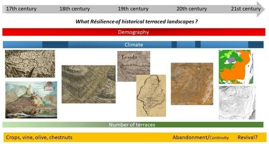
:Highlights
- Terraced lands are a historical landscape under risk in Mediterranean mountains;
- Their surface and land-use trajectories are analyzed across five centuries in a GIS;
- Although mostly abandoned, they persist in the ground landscape;
- Their environmental and productive functions are part of their future resilience.
Abstract
1. Introduction
2. Materials and Methods
2.1. Study Site
2.2. Materials
2.2.1. Terrace Mapping
- LIDAR HD
- Plots of land layer
- Aerial photography 1947–1951
- Data analysis in a GIS
2.2.2. Land-Use Change Mapping
- Building a multi-date geographical database
- Old maps analysis
- Napoleonic cadaster
- Aerial photography 1947–1951
- BD TOPO 2023
- Data criticism
2.3. Data Analysis
3. Results
3.1. Terraces and Land Use
3.2. Trajectories of Land Use
4. Discussion
4.1. How Many Terraces?
4.2. Time Variation
- 1672–1749
- 1749–1850
- 1850–1947
- 1947–2023
4.3. Spatial Analysis
4.4. Resilience of Historical Landscapes
4.5. Limits and Prospects of Our Study
5. Conclusions
Supplementary Materials
Author Contributions
Funding
Data Availability Statement
Acknowledgments
Conflicts of Interest
References
- De Reparaz, A. La culture en terrasses, expression de la petite paysannerie méditerranéenne traditionnelle. Méditerranée 1990, 71, 23–29. Available online: https://www.persee.fr/doc/medit_0025-8296_1990_num_71_3_2679 (accessed on 1 April 2023). [CrossRef]
- Varotto, M.; Bonardi, L.; Tarolli, P. (Eds.) World Terraced Landscapes: History, Environment, Quality of Life; Environmental History book series (Envhis) Volume 9; Springer: Cham, Switzerland, 2019. [Google Scholar] [CrossRef]
- Wolpert, F.; Quintas-Soriano, C.; Plieninger, T. Exploring land-use histories of tree-crop landscapes: A cross-site comparison in the Mediterranean Basin. Sustain. Sci. 2020, 15, 1267–1283. [Google Scholar] [CrossRef]
- FAO. Globally Agricultural Heritage Systems. Available online: https://www.fao.org/giahs/fr/ (accessed on 1 April 2023).
- Cumming, G.S. Spatial resilience: Integrating landscape ecology, resilience, and sustainability. Landsc. Ecol. 2021, 26, 899–909. [Google Scholar] [CrossRef]
- Vallés-Planells, M.; Galiana, F.; Torrijos, I.D. Agricultural abandonment and resilience in a Mediterranean periurban traditional agroecosystem: A landscape approach. Ecol. Soc. 2020, 25, 5. [Google Scholar] [CrossRef]
- Surell, A. Étude sur les Torrents des Hautes-Alpes; Carilian-Gœury et Victor Dalmont: Paris, France, 1841. [Google Scholar]
- Bravard, J.P. Le traitement des versants dans le Département de la Drome. Des inondations de 1840 à la loi du 27 juillet 1860. Ann. Des Ponts Et Chaussées 2002, 103, 37–43. [Google Scholar] [CrossRef]
- Descroix, L.; Gautier, E. Water erosion in the southern French Alps: Climatic and human mechanisms. Catena 2002, 50, 53–85. [Google Scholar] [CrossRef]
- García-Ruiz, J.M.; Lana-Renault, N. Hydrological and erosive consequences of farmland abandonment in Europe, with special reference to the Mediterranean region—A review. Agric. Ecosyst. Environ. 2011, 140, 317–338. [Google Scholar] [CrossRef]
- Benito, G.; Macklin, M.G.; Zielhofer, C.; Jones, A.F.; Machado, M.J. Holocene flooding and climate change in the Mediterranean. Catena 2015, 130, 13–33. [Google Scholar] [CrossRef]
- Wilhelm, B.; Rapuc, W.; Amann, B.; Anselmetti, F.S.; Arnaud, F.; Blanchet, J.; Brauer, A.; Czymzik, M.; Giguet-Covex, C.; Gilli, A.; et al. Impact of warmer climate periods on flood hazard in the European Alps. Nat. Geosci. 2022, 15, 118–123. [Google Scholar] [CrossRef]
- Ginesta, M.; Yiou, P.; Messori, G.; Faranda, D. A methodology for attributing severe extratropical cyclones to climate change based on reanalysis data: The case study of storm Alex 2020. Clim. Dyn. 2023, 61, 229–253. [Google Scholar] [CrossRef]
- Tramblay, Y.; Somot, S. Future evolution of extreme precipitation in the Mediterranean. Clim. Chang. 2018, 151, 289–302. [Google Scholar] [CrossRef]
- Kreibich, H.; Van Loon, A.F.; Schröter, K.; Ward, P.J.; Mazzoleni, M.; Sairam, N.; Abeshu, G.W.; Agafonova, S.; AghaKouchak, A.; Aksoy, H.; et al. The challenge of unprecedented floods and droughts in risk management. Nature 2022, 608, 80–86. [Google Scholar] [CrossRef] [PubMed]
- Brown, A.G.; Fallu, D.; Walsh, K.; Cucchiaro, S.; Tarolli, P.; Zhao, P.; Pears, B.R.; van Oost, K.; Snape, L.; Lang, A.; et al. Ending the Cinderella status of terraces and lynchets in Europe: The geomorphology of agricultural terraces and implications for ecosystem services and climate adaptation. Geomorphology 2021, 379, 107579. [Google Scholar] [CrossRef]
- Stanchi, S.; Freppaz, M.; Agnelli, A.; Reinsch, T.; Zanini, E. Properties, best management practices and conservation of terraced soils in Southern Europe (from Mediterranean areas to the Alps): A review. Quat. Inter. 2012, 265, 90–100. [Google Scholar] [CrossRef]
- Dorren, L.; Rey, F. A review of the effect of terracing on erosion. In Briefing Papers of the 2nd SCAPE Workshop; Boix-Fayons, C., Imeson, A., Eds.; 2004; pp. 97–108. Available online: https://www.ecorisq.org/docs/Dorren_Rey.pdf (accessed on 1 April 2023).
- Arnáez, J.; Lana-Renault, N.; Lasanta, T.; Ruiz-Flaño, P.; Castroviejo, J. Effects of farming terraces on hydrological and geomorphological processes. A review. Catena 2015, 128, 122–134. [Google Scholar] [CrossRef]
- Boillat, S.; Burga, C.A.; Gigon, A.; Backhaus, N. La succession végétale sur les cultures en terrasses de la Vallée de la Roya (Alpes-Maritimes, France) et sa perception par la population locale. Geogr. Helv. 2004, 59, 154–167. [Google Scholar] [CrossRef]
- Slámová, M.; Krčmářová, J.; Hronček, P.; Kaštierová, M. Environmental factors influencing the distribution of agricultural terraces: Case study of Horný Tisovník, Slovakia. Morav. Geogr. Rep. 2017, 25, 34–45. [Google Scholar] [CrossRef]
- Angles, S.; Grésillon, E.; Minvielle, P. L’oléiculture en France: Quand le paysage participe au renouveau d’une activité agricole. Proj. Paysage 2017, 17, 4157. [Google Scholar] [CrossRef]
- Cohen, M.; Godron, M.; Cretin-Pablo, R.; Pujos, R. Plant biodiversity in Mediterranean orchards is related to historical land use: Perspectives for biodiversity-friendly olive production. Reg. Environ. Chang. 2023, 23, 70. [Google Scholar] [CrossRef]
- Antrop, M. Why landscapes of the past are important for the future. Landsc. Urban Plan. 2005, 70, 21–34. [Google Scholar] [CrossRef]
- Lasanta, T.; Arnáez, J.; Pascual, N.; Ruiz-Flaño, P.; Errea, M.P.; Lana-Renault, N. Space–time process and drivers of land abandonment in Europe. Catena 2017, 149, 810–823. [Google Scholar] [CrossRef]
- Luginbuhl, Y.; Howard, P.; Terrasson, D. (Eds.) Landscape and Sustainable Development, The French Perspective; Routledge: London, UK, 2016. [Google Scholar]
- Duby, G. Histoire de la France Rurale; Tomes 1-2-3-4; Editions du Seuil: Paris, France, 1992. [Google Scholar]
- Diarte-Blasco, P.; Castro-Priego, M. Is Historical Cartography a Useful Tool for Landscape Analysis? A Perspective from Inland Spain (Zorita de los Canes, Guadalajara) from the Middle Ages to the Present. Land 2023, 12, 1627. [Google Scholar] [CrossRef]
- Diaz-Varela, R.A.; Zarco-Tejada, P.J.; Angileri, V.; Loudjani, P. Automatic identification of agricultural terraces through object-oriented analysis of very high resolution DSMs and multispectral imagery obtained from an unmanned aerial vehicle. J. Environ. Manag. 2014, 134, 117–126. [Google Scholar] [CrossRef] [PubMed]
- Vallauri, D.; Grel, A.; Granier, E.; Dupouey, J.L. Les forêts de Cassini. Analyse Quantitative et Comparaison Avec les Forêts Actuelles; [Technical report]; Rapport WWF/INRA, Marseille; 2012; Available online: https://hal.science/hal-01267936 (accessed on 1 April 2023).
- Herrault, P.A.; Sheeren, D.; Fauvel, M.; Monteil, C.; Paegelow, M. A comparative study of geometric transformation models for the historical “Map of France” registration. Geogr. Tech. 2013, 1, 34–46. [Google Scholar]
- Cohen, M.; Alexandre, F.; Mathieu, N. Modelling interactions between biophysical and social systems: The example of bush progression in Causse Méjan. CyberGeo 1998, 39, 1551. [Google Scholar] [CrossRef]
- Font, P.G. Sobre la datación y límites de las terrazas de cultivo. Algunas observaciones de campo. In Paisaje, Cultura Territorial y Vivencia de la Geografía: Libro Homenaje al Profesor Alfredo Morales Gil; Instituto Interuniversitario de Geografía: Alicante Universidad, Spain, 2016; pp. 111–124. [Google Scholar]
- Lieskovský, J.; Lieskovský, T.; Hladíková, K.; Štefunková, D.; Hurajtová, N. Potential of airborne LiDAR data in detecting cultural landscape features in Slovakia. Landsc. Res. 2022, 47, 539–554. [Google Scholar] [CrossRef]
- Inomata, T.; Triadan, D.; Pinzón, F.; Burham, M.; Ranchos, J.L.; Aoyama, K.; Haraguchi, T. Archaeological application of airborne LiDAR to examine social changes in the Ceibal region of the Maya lowlands. PLoS ONE 2018, 13, e0191619. [Google Scholar] [CrossRef] [PubMed]
- Matyukira, C.; Mhangara, P. Advancement in the Application of Geospatial Technology in Archaeology and Cultural Heritage in South Africa: A Scientometric Review. Remote Sens. 2023, 15, 4781. [Google Scholar] [CrossRef]
- Trier, Ø.D.; Reksten, J.H.; Løseth, K. Automated mapping of cultural heritage in Norway from airborne lidar data using faster R-CNN. Int. J. Appl. Earth Obs. Geoinf. 2021, 95, 102241. [Google Scholar] [CrossRef]
- Castex, J.M. L’aménagement des pentes et des sols dans les Alpes-Maritimes et le Var. Méditerranée 1983, 47, 3–15. [Google Scholar] [CrossRef]
- Benjeddou, M.; Dagorne, A.; Castex, J.-M.; Davtian, G. Maps and comments concerning some terraced sites of the Alpes-Maritimes (06-F): Granile (Tende), Roquebilière, Auribeau. In Terraced Landscapes of the Alpine Arc, Atlas/Interpretations, Project Alpter; Marsilio Editore: Milano, Italy, 2008; pp. 76–79. [Google Scholar]
- Sumera, F. Signature des Occupations Protohistoriques et Antiques dans L’évolution des Paysages et Dans la Construction de la Géographie Humaine du Massif du Mercantour (Alpes-Maritimes). Ph.D. Thesis, University Aix-Marseille, Marseille, France, 2015. [Google Scholar]
- Bourrier, M.; Bourrier-Reynaud, C. Le Comté de Nice: Enjeu et Théâtre de Cinq Siècles de Guerres Pour Devenir Français (1388–1860). In Fortifications et Frontières Entre Guerre et Paix. Actes du 136e Congrès National des Sociétés Historiques et Scientifiques, «Faire la Guerre, Faire la Paix», Perpignan, 2011; Editions du CTHS: Paris, France, 2015; pp. 21–33. Available online: https://www.persee.fr/doc/acths_1764-7355_2015_act_136_12_2749#:~:text=Le%2024%20mars%201860%2C%20en,la%20Savoie%20contre%20la%20Lombardie (accessed on 1 April 2023).
- Costamagna, H. Les guerres et leurs conséquences dans le Comté de Nice au XVIIIe siècle. Cah. Méditerranée 1973, 6, 77–93. Available online: https://www.persee.fr/doc/camed_0395-9317_1973_num_6_1_1377 (accessed on 1 April 2023). [CrossRef]
- Guiot, L. Les Forêts et les Pâturages du Comte de Nice, Mémoire de la Société Générale d’Agriculture de France; Imprimerie Bouchard-Huzard: Paris, France, 1875; Available online: https://gallica.bnf.fr/ark:/12148/bpt6k6540493n.texteImage (accessed on 1 April 2023).
- Casalis, G. Dizionario Geografico Storico Statistico Commerciale Compilato per Cura del Professore e Dottore di Belle Lettere, Cavaliere Dell’ordine de SS Maurizio e Lazzaro Opera Molto Utile Agli Impiegati nei Pubblici e Private Uffizi a Tutte le Persone Applicate al Foro Alla Milizia al Commercio e Singolarmente Agli Amatori Delle Cose Patrie. 1855. Available online: http://www.Archeo-alpi-maritimi.com/ethno_hautes_vallees.php (accessed on 1 April 2023).
- Casimir, J. Statistique Agricole de la France. Monographie Agricole du Département des Alpes Maritimes, Vol. MCMXXXVII, 1929. Available online: https://gallica.bnf.fr/ (accessed on 1 April 2023).
- Pichard, G.; Provansal, M.; Sabatier, F. Les embouchures du Rhône. L’apport de la cartographie à l’étude de leur évolution géomorphologique au cours du Petit âge glaciaire (PAG). Méditerranée 2014, 122, 43–59. [Google Scholar] [CrossRef]
- Fouache, E.; Desruelles, S.; Gorini, C.; Bianchi, N.; Marchiel, A. Evaluation of the return time of flash floods generated in the Roya Valley (Alpes Maritime, France) on October 2, 2020: What challenges does this type of event pose for risk management? In Proceedings of the Copernicus Meetings No. ICG2022-7, Coimbra, Portugal, 12–16 September 2022. [Google Scholar] [CrossRef]
- Kerverdo, R.; Marchiel, A.; Gorini, C.; Lafuerza, S.; Fouache, E. Extreme debris flows events recorded on Roya river tributaries: What challenges does this type of event pose for risk management? In Proceedings of the 6th World Landslides Forum, Florence, Italy, 14–17 November 2023. [Google Scholar]
- Carrega, P.; Michelot, N. Une catastrophe hors norme d’origine météorologique le 2 octobre 2020 dans les montagnes des Alpes-Maritimes. An over-standing disaster of meteorological origin on October 2, 2020, in the mountains of the Alpes-Maritimes. Physiogéo 2021, 16, 1–70. [Google Scholar] [CrossRef]
- Piton, G.; Cohen, M.; Flipo, M.; Nowak, M.; Chapuis, M.; Melun, G.; Robert, Y.; Andréis, N.; Liebault, F. Large in-stream wood yield during an extreme flood (Storm Alex, October 2020, Roya Valley, France): Estimating the supply, transport, and deposition using GIS. Geomorphology 2023, 446, 108981. [Google Scholar] [CrossRef]
- Balletti, C. Georeference in the analysis of the geometric content of early maps. e-Perimetron 2006, 1, 32–39. Available online: https://www.e-perimetron.org/Vol_1_1/Balletti/Balletti.pdf (accessed on 1 April 2023).
- Vignal, M. L’impact du Changement Global sur la Flore du Sud-Est de la France: Modélisation Multiscalaire de la Répartition de 25 Espèces à L’horizon 2100 par la Dynamique de Population. Ph.D. Thesis, University of Nice, Nice, France, 2020. Available online: https://theses.hal.science/tel-03105744 (accessed on 1 April 2023).
- Andrieu, J.; Lombard, F.; Vignal, M.; Godron, M.; Alexandre, F. A phyto-climatic transect in the Alpes Maritimes used to characterize the northern limit of the Mediterranean biogeographical area. Biodivers. J. 2020, 11, 679–688. [Google Scholar] [CrossRef]
- Wagner, E. Mémoire sur la Reconnaissance des Hauteurs Entre la Vésubie et la Roya Occupées par les Armées Française et Austro-Sarde en 1742, 1793,1794, Collection du Ministere de la Défense, SHD, Département de L’armée de Terre, 1 VD 34art 4 sect 1 parag 5, 4° C1 N° 54. 1865. Available online: http://www.archeo-alpi-maritimi.com/ethno_hautes_vallees.php (accessed on 1 April 2023).
- SHD. Routes d’Antibes à Coni et de Coni à Asti, et la Traversée d’Antibes à Barcelonnette. 1 VD 34 art 4 sect 1 parag 5, 1736, 4° C1, N°13, Collection du Ministère de la Défense, SHD, Département de L’armée de Terre. 1736. Available online: http://www.archeo-alpi-maritimi.com (accessed on 1 April 2023).
- Costamagna, H. Le Comté de Nice Au XVIIIe Siècle. Introduction à la Thèse De 3e Cycle Recherches sur les Institutions Communales Dans le Comté de Nice au XVIIIe Siècle (1699–1792), Université de Nice. 1971. Available online: https://www.departement06.fr/documents/Import/decouvrir-les-am/rr46-1973-n2-02.pdf (accessed on 1 April 2023).
- Parcs Naturels régionaux de France. Terrasses agricoles. Gestion des espaces naturels, agricoles et forestiers. In Collection Expérimenter Pour Agir; Fédération des parcs régionaux: Paris, France, 2000. [Google Scholar]
- Rebours, F. Versants aménages et déprise rurale dans l’est des Alpes-Maritimes. Méditerranée 1990, 71, 31–36. Available online: https://www.persee.fr/doc/medit_0025-8296_1990_num_71_3_2680 (accessed on 1 April 2023). [CrossRef]
- Gennai-Schott, S.; Sabbatini, T.; Rizzo, D.; Marraccini, E. Who remains when professional farmers give up? Some insights on hobby farming in an olive groves-oriented terraced Mediterranean area. Land 2020, 9, 168. [Google Scholar] [CrossRef]
- Desbordes, E. Les Paysages de Terrasses Agricoles Dans le Bassin Méditerranéen Septentrional. Etude Comparée des Alpes Maritimes et de la Ligurie. Ph.D. Thesis, Université de Limoges, Limoges, France, 1999. Available online: https://theses.fr/1999LIMO2002 (accessed on 1 April 2023).
- Kinnaird, T.; Bolos, J.; Turner, A.; Turner, S. Optically-stimulated luminescence profiling and dating of historic agricultural terraces in Catalonia (Spain). J. Archaeol. Sci. 2017, 78, 66–77. [Google Scholar] [CrossRef]


| Date | Name | Author [Source] | Scale | Georf | Topo | Land Use | Forest | Gaps |
|---|---|---|---|---|---|---|---|---|
| 1672–1675 | Carta generale de stati di sua Altezza Reale | Cartographer GT. Borgonio, [www.gallica.fr, accessed on 1 April 2023] | 1/90,000 | no | rough | Intercrop, tree-crop | No | Eastern slopes |
| 17th | Engravings (Saorge and Tende) | GT. Borgonio [www.archives06.fr, accessed on 1 April 2023] | ND | no | rough | Detailed | No | no |
| 1749–1754 | Carte géométrique du comté de Nice | Engeneer P.J. Bourcet [https://www.servicehistorique.sga.defense.gouv.fr/le-shd-en-france/vincennes-centre-historique-des-archives, accessed on 1 April 2023] | 1/14,400 | no | rough | Intercrop, crop, tree-crop | No | Western slopes, northern limit |
| 1850 | Carta topografica degli Stati in terraferma di S. M. Il Re di Sardegna | Royal staff corps [https://www.defense.gouv.fr/academ/membres-lacadem/bibliotheque-lecole-militaire, accessed on 1 April 2023] | 1/50,000 Sheet no. NLXXXI | no | regular | Crop, pasture, wood, olive, vine | Yes | no |
| 1864–1866 | Napoleonic cadaster | French State, [www.archives06.fr, accessed on 1 April 2023, 40] | 2500 | yes | no | Crop, pasture, wood, olive, vine | Yes | no |
| 1947–1951 | Aerial photography | IGN [www.geoservices.ign.fr, accessed on 1 April 2022] | 1/40,000 | yes | no | Visual interpretation of the proportion of the plot covered with scrubland and forest | no | |
| 2023 | BD TOPO, Zone de Végétation | 1/25,000 | yes | no | Crops, pasture, orchards in 2020 | |||
| 2023 | Plots of land | 1/25,000 | yes | no | No | no | ||
| 2020 | Lidar HD post-Storm Alex | DEM 1 m resolution | yes | good | No | no | ||
| 2023 | Lidar HD 06 | yes | good | No | no | |||
| Municipality | 1672–1675 | 1749–1754 | 1850–1864 | 1947–1951 | 2020–2023 | Total Surface Area |
|---|---|---|---|---|---|---|
| Tende | 3.09 | 6.96 | 20.28 | 15 | 4.69 | 177.47 |
| La Brigue | 3.63 | 4.89 | 10.66 | 6.9 | 0.73 | 91.77 |
| Fontan | 3.70 | 3.86 | 8.45 | 5 | 1.35 | 49.61 |
| Saorge | 4.27 | 7.60 | 8.77 | 5.7 | 1.46 | 86.78 |
| Breil-sur-Roya | 2.76 | 7.41 | 16.43 | 11.5 | 3.85 | 81.31 |
| Moulinet | 3.34 | 1.70 | 6.08 | 2.8 | 0.30 | 41.07 |
| Sospel | 5.80 | 14.13 | 17.72 | 11.8 | 4.26 | 62.48 |
| Total | 26.62 | 48.79 | 90.8 | 61.1 | 16.86 | 636.46 |
| Municipality | Crops | Pasture | Chesnut | Vine | Olive | Intercrop |
|---|---|---|---|---|---|---|
| Tende | 6.6 | 2.0 | 2.6 | 0.1 | 0 | 0.6 |
| La Brigue | 9.1 | 0.4 | 1.3 | 0.9 | 0 | 0.1 |
| Fontan | 13.0 | 1.6 | 1.3 | 1.4 | 0.1 | 0.2 |
| Saorge | 6.5 | 0.4 | 0.1 | 2.5 | 0.5 | 0.2 |
| Moulinet | 10.5 | 2.7 | 0 | 1.0 | 0 | 0.1 |
| Breil-sur-Roya | 10.8 | 0.9 | 0.9 | 2.4 | 4.8 | 1.8 |
| Sospel | 11.9 | 2.2 | 0 | 4.1 | 8.6 | 1.2 |
| Trajectory | Land Use | Breil | Fontan | La Brigue | Moulinet | Saorge | Sospel | Tende | Total | |
|---|---|---|---|---|---|---|---|---|---|---|
| s/Roya | ||||||||||
| since 17–18 th centuries | abandoned | chestnut | 21 | 1 | 31 | 30 | 1 | 134 | 217 | |
| crops | 334 | 334 | 380 | 243 | 485 | 543 | 273 | 2591 | ||
| olive | 122 | 4 | 50 | 317 | 0 | 493 | ||||
| pasture | 29 | 44 | 1 | 56 | 34 | 104 | 34 | 302 | ||
| vine | 123 | 25 | 78 | 38 | 160 | 167 | 21 | 613 | ||
| cropped | chestnut | 4 | 12 | 2 | 1 | 7 | 176 | 202 | ||
| crops | 21 | 15 | 7 | 4 | 9 | 26 | 38 | 119 | ||
| olive | 143 | 0 | 4 | 166 | 313 | |||||
| pasture | 1 | 4 | 5 | 4 | 15 | |||||
| vine | 0 | 1 | 0 | 0 | 1 | |||||
| conversion | 127 | 12 | 27 | 5 | 11 | 142 | 16 | 341 | ||
| since 19th century | abandoned | chestnut | 24 | 43 | 0 | 117 | 184 | |||
| crops | 457 | 238 | 403 | 122 | 125 | 778 | 2123 | |||
| olive | 34 | 3 | 5 | 15 | 58 | |||||
| pasture | 48 | 30 | 37 | 55 | 3 | 27 | 294 | 496 | ||
| vine | 25 | 35 | 9 | 16 | 1 | 86 | ||||
| cropped | chestnut | 22 | 53 | 37 | 1 | 1 | 37 | 152 | ||
| crops | 7 | 12 | 3 | 1 | 3 | 48 | 74 | |||
| olive | 13 | 0 | 2 | 15 | ||||||
| pasture | 0 | 0 | 0 | 19 | 20 | |||||
| conversion | 26 | 3 | 1 | 1 | 0 | 2 | 10 | 43 | ||
Disclaimer/Publisher’s Note: The statements, opinions and data contained in all publications are solely those of the individual author(s) and contributor(s) and not of MDPI and/or the editor(s). MDPI and/or the editor(s) disclaim responsibility for any injury to people or property resulting from any ideas, methods, instructions or products referred to in the content. |
© 2024 by the authors. Licensee MDPI, Basel, Switzerland. This article is an open access article distributed under the terms and conditions of the Creative Commons Attribution (CC BY) license (https://creativecommons.org/licenses/by/4.0/).
Share and Cite
Le Vot, T.; Cohen, M.; Nowak, M.; Passy, P.; Sumera, F. Resilience of Terraced Landscapes to Human and Natural Impacts: A GIS-Based Reconstruction of Land Use Evolution in a Mediterranean Mountain Valley. Land 2024, 13, 592. https://doi.org/10.3390/land13050592
Le Vot T, Cohen M, Nowak M, Passy P, Sumera F. Resilience of Terraced Landscapes to Human and Natural Impacts: A GIS-Based Reconstruction of Land Use Evolution in a Mediterranean Mountain Valley. Land. 2024; 13(5):592. https://doi.org/10.3390/land13050592
Chicago/Turabian StyleLe Vot, Titouan, Marianne Cohen, Maciej Nowak, Paul Passy, and Franck Sumera. 2024. "Resilience of Terraced Landscapes to Human and Natural Impacts: A GIS-Based Reconstruction of Land Use Evolution in a Mediterranean Mountain Valley" Land 13, no. 5: 592. https://doi.org/10.3390/land13050592