

Land 2024, 13(5), 589; https://doi.org/10.3390/land13050589 (registering DOI) - 28 Apr 2024
Abstract
Specific environmental characteristics can encourage active leisure travel and increase physical activity. However, existing environment-travel studies tend to ignore the differences in environmental characteristics associated with route choice and travel distance, of which the latter could be more important for health benefits, since
[...] Read more.
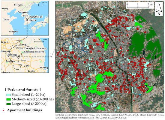
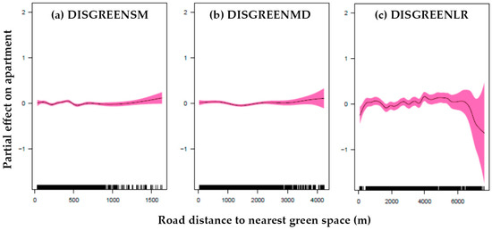
Specific environmental characteristics can encourage active leisure travel and increase physical activity. However, existing environment-travel studies tend to ignore the differences in environmental characteristics associated with route choice and travel distance, of which the latter could be more important for health benefits, since longer trips are associated with increased exercise. Additionally, the most recent studies focus on leisure walking and leisure cycling, and activities such as hiking, climbing, and running are examined less frequently. This study, therefore, compares the similarities and differences of the environmental factors associated with route selection and travel distance through non-parametric tests and Cox proportional hazard models. The results show that two intersecting sets of environmental elements relate to both the route chosen and the distance traveled. Land use diversity and varied topography are appealing for both leisure trips and trip length. In addition, the differences in environmental characteristics among specific leisure travels may be attributed to variations in physical activity requirements, preferences for landscape viewing, and/or sensitivity to crowding. Therefore, conclusions drawn without considering the different types of leisure travel could be skewed. Whether particular surroundings may effectively increase physical activity remains uncertain. A more holistic perspective could be beneficial when studying the connection between the environment, active travel, and health.
Full article
(This article belongs to the Topic Healthy and Sustainable Living Environments: Green and Blue Spaces)


