

Drones 2024, 8(5), 198; https://doi.org/10.3390/drones8050198 - 14 May 2024
Abstract
In the context of rapidly advancing agricultural technology, precise and efficient methods for crop detection and counting play a crucial role in enhancing productivity and efficiency in crop management. Monitoring corn tassels is key to assessing plant characteristics, tracking plant health, predicting yield,
[...] Read more.
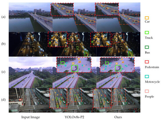
In the context of rapidly advancing agricultural technology, precise and efficient methods for crop detection and counting play a crucial role in enhancing productivity and efficiency in crop management. Monitoring corn tassels is key to assessing plant characteristics, tracking plant health, predicting yield, and addressing issues such as pests, diseases, and nutrient deficiencies promptly. This ultimately ensures robust and high-yielding corn growth. This study introduces a method for the recognition and counting of corn tassels, using RGB imagery captured by unmanned aerial vehicles (UAVs) and the YOLOv8 model. The model incorporates the Pconv local convolution module, enabling a lightweight design and rapid detection speed. The ACmix module is added to the backbone section to improve feature extraction capabilities for corn tassels. Moreover, the CTAM module is integrated into the neck section to enhance semantic information exchange between channels, allowing for precise and efficient positioning of corn tassels. To optimize the learning rate strategy, the sparrow search algorithm (SSA) is utilized. Significant improvements in recognition accuracy, detection efficiency, and robustness are observed across various UAV flight altitudes. Experimental results show that, compared to the original YOLOv8 model, the proposed model exhibits an increase in accuracy of 3.27 percentage points to 97.59% and an increase in recall of 2.85 percentage points to 94.40% at a height of 5 m. Furthermore, the model optimizes frames per second (FPS), parameters (params), and GFLOPs (giga floating point operations per second) by 7.12%, 11.5%, and 8.94%, respectively, achieving values of 40.62 FPS, 14.62 MB, and 11.21 GFLOPs. At heights of 10, 15, and 20 m, the model maintains stable accuracies of 90.36%, 88.34%, and 84.32%, respectively. This study offers technical support for the automated detection of corn tassels, advancing the intelligence and precision of agricultural production and significantly contributing to the development of modern agricultural technology.
Full article
(This article belongs to the Special Issue Advances of UAV in Precision Agriculture)
►
Show Figures

Figure 1


